It wasn’t that long ago that any mention of drones in the news seemed to be associated with military strikes on international terrorists. But it may not be long from now that talk of drones (or unmanned aerial vehicles - UAVs), will primarily be associated with medical and package deliveries, and commercial passenger drone services or “air taxis.” A new class at Catawba College aims to help prepare students to take advantage of this changing reality.
Dr. Andrew Jacobson, assistant professor of GIS and Conservation in Catawba’s Department of the Environment and Sustainability and an FAA certified small drone pilot, is building the curriculum. This is the first year Catawba has offered a class on drones. The course aims to inspire and teach students the use of drones and to understand the regulations surrounding them. This course will give students hands-on experience flying different types of drones, learning how to do so safely and how to efficiently collect data for a variety of applications.
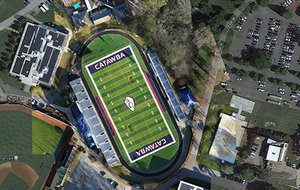
“The class fits really well into our new Geographic Information Systems (GIS) and Technology minor at Catawba,” Dr. Jacobson said. GIS is a multi-billion dollar industry with strong growth outlook and is widely used in government, transportation, and environmental sectors. Drones are increasingly used for mapping purposes and collecting very high-resolution imagery data that is integrated into GIS. UAVs are a safe, and relatively cheap and easy way to get on-demand aerial photographs. The landscape can be analyzed itself (e.g. to determine land cover), turned into a 3-D elevation model to look at drainage patterns, for instance, or simply used a basemap for other data. The aerial perspective that drones provide is becoming essential in a number of industries such as daily updates of a construction site, continuous monitoring of a disaster relief operation, crop monitoring, and before/after photos for disaster insurance claims.
Kyle Snyder, Class of ’96, is Robotics Program Manager for the Cherokee Nation Stratetic Programs.
"Since graduating from Catawba, I have spent most of my career developing the drone industry in various roles,” he said. “It's exciting to see today the technology fulfilling the potential to impact so many lives in commercial applications. The integration of robotics, including drones, across manufacturing, logistics, healthcare, entertainment, and science is creating opportunities for students that know how and when to apply technology in everyday lives. As an alumnus, I look forward to seeing how this class at Catawba unlocks new ideas for students.”
Harmony Mason, a sophomore at Catawba, said that she is excited to be a part of the first drones course at Catawba. “I took it partly on a whim because it sounded exciting and would fit into my GIST Minor, she said. “But now that I’m in the course, I can really see the tremendous array of applications and it gets me motivated to get my own drone and to look for additional opportunities to fly.”
Matt Baity, a senior, added, “I plan on becoming FAA certified so that I can be a commercial drone pilot and leverage that as a marketable skill in the job market. It’s crazy to think about, but when I come back to Catawba for my 15- or 20-year reunion, I may be able to get here on an air taxi. I’ve been convinced, the future of the industry is now.”